Topographic Mapping with Drones
Getting more out of your imaging
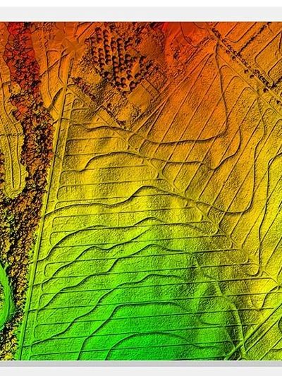
At Active Drone Solutions, we specialize in providing highly accurate and detailed topographic mapping services using advanced drone technology. Our topographic solutions empower clients to make informed decisions about land use, environmental management, and project planning.
Comprehensive Topographic Data Collection
Using state-of-the-art drones, we capture high-resolution images of the landscape, which are processed into precise topographic maps and models. Depending on your needs, we can deliver:
- Digital Surface Models (DSM): Representing the Earth’s surface, including natural and built features.
- Digital Elevation Models (DEM): Highlighting ground elevation with all features removed.
- Digital Terrain Models (DTM): Providing detailed terrain structure for engineering and environmental assessments.

Advanced Processing with Agisoft MetaShape Pro
To create these topographic products, we process drone-collected data with Agisoft MetaShape Pro, ensuring exceptional accuracy and quality. Our deliverables are designed to be compatible with industry-standard software, including:
- Pix4D
- DroneDeploy
Flexible Deliverables for Your Needs
We offer topographic deliverables in a variety of formats to suit your workflow:
- Raster Formats: Standard TIFF with world files for georeferencing, or other formats like BIL, XYZ, and KML upon request.
- Vector Contours: Delivered in Arc SHAPE, DXF, KML, KMZ, TXT, and other standard formats.
This flexibility ensures seamless integration with your GIS and CAD systems.
Why Topographic Mapping Matters
Topographic data is critical for understanding natural hazards and their impact on human activities. It plays a vital role in:
- Slope Instability and Erosion Analysis: Identifying areas at risk of landslides or soil erosion.
- Disaster Planning: Predicting and preparing for potential environmental risks, such as flooding or contamination leaks.
- Environmental Management: Monitoring how human activities affect the natural landscape over time.
By analyzing topographic data, industries like oil and gas, construction, and environmental management can plan and execute projects with confidence.
